 |
| City of Toronto News |
This is really a beautiful example of lake effect cloud formation over Lake Michigan. Keep this phenomena in mind as it will help you appreciate what I am going to post about next on some newer findings of California's irrigated lands in the Central Valley having effect on rainfall totals in other areas like the 4 corners states (Utah, Arizona, New Mexico & Colorado). I know, almost hard to believe, but it's really interesting.
 |
| Lake-effect snow process - NOAA |
With some of this info above in mind, that takes me to an article I read around the 1st of February 2013 in Science Mag online entitled: California Irrigation Changing Weather Patterns in American Southwest which spoke of California's Central Valley being heavily irrigated for agriculture where much of that is going towards evaporation and actually influencing weather even a few states away. You can read the entire article from the link above. I'll quote just a few important paragraphs to point out some pertinent issues and some personal conclusions I've had and always wondered about with ancient Lake Cahuilla in Riverside & Imperial counties of southern California.
NOAA-GOES-8 visible animation shows a lake-effect cloud plume over Lake Michigan's wamer water during the morning hours with heavier clouds with snow later on.
"Every year, several cubic kilometers of water are supplied to the Central Valley's fields, about 60% of it from river flow diverted into the region and the rest from wells. A significant amount of that liquid evaporates from fields rather than nourishing crops, says James Famiglietti, a hydrologist at the University of California (UC), Irvine. That boosts humidity in the valley, according to previous research, but scientists haven't evaluated its effects farther afield."
 |
| Graphic © Min-Hui and Famiglietti / Geophysical Research Letters |
This schematic shows the “anthropogenic loop” in the summer water cycle in the U.S. Southwest, as revealed by computer modeling that compared current levels of irrigation in California’s Central Valley to a scenario in which no irrigation takes place. The blue arrows represent changes in the amount of water vapor that is transported into and out of the Southwest, while the red arrows show the processes of evaporation, precipitation, and runoff within the region.
"The extra moisture boosted rainfall as far away as western Nebraska and the panhandle of Oklahoma, the team reports in Geophysical Research Letters. Most notably, parts of southern Wyoming and the Four Corners states—Utah, Colorado, Arizona, and New Mexico—received between 4 and 14 millimeters more precipitation each June, July, and August. Overall, that boosts summer rainfall in those areas by 15% above average, which in turn increases runoff into the Colorado River by 28%."
(Source)So that was interesting. They are speculating that such massive quantities of water evaporation have a strong influence on weather hundreds of miles away. They mention the influence of wetter weather in western Utah, Wyoming and Nebraska and that would make sense as these areas are along the same level, but the actual four corners region is much further south and they were talking about increases in rainfall in July/August which would translate Monsoon Season. But then I also know that most Monsoonal Moisture comes up from Mexico in the summer time, not necessarily from the west and north. Here now this next paragraph gives us something of a hint which even more intriguing as far as water source influence over the four corners region of the southwest. Take a look below.
But not all of the enhanced rainfall comes from California moisture, the team notes. As water vapor in the air condenses, it releases prodigious amounts of heat. When that hot air rises, it creates low pressure at ground level in the region surrounding the storms and draws in moist air from surrounding regions, including the Gulf of California (also known as the Sea of Cortez) and the Gulf of Mexico. "The added moisture really fires up the storm cycle" in the Southwest, Famiglietti says.
 |
Map of the current Salton Sea boundaries and outline of Lake Cahuilla at its peak size as well as locations of major area faults |
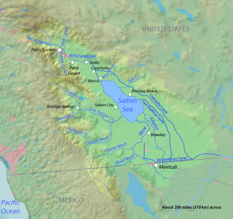
Okay, so that helps, but it also triggers something I've always pondered over as far as any type of weather influence of the very large ancient Lake Cahuilla. Many years ago in one of my 1980s issues of Arizona Highways magazine there was an article on Salton Sink and an old west era scheme that was proposed on diverting the Colorado River or opening a canal to the Sea of Cortez and filling up the basin to capacity which was thought would moderate Arizona's hot climate. Of course this never happened and the present sea was created through an error in bringing irrigation water to the valley for farmer around 1904 or 05. But it got me thinking about the weather cooling effects of just such a large body of water on areas east. This same magazine had also published articles of how Science had determined that western Arizona which is less vegetated now than near Tucson's green living Sonoran Desert at one time was much like that present area today, with even some of the higher desert mountains having some Pinyon and Juniper woodlands on this landscape.

Okay, so I have always wondered not ONLY if this ancient sea or fresh water (maybe brackish) lake had an influence on western Arizona desert, but also if it had an influence on the four corners Colorado Plateau region where the Anasazi lived and possibly influenced the climate there when it was in it's heavier forested state. I know there are numerous accounts and circumstantial evidence of Anasazi deforestation and mismanagement of the land, but could also the time frame of the Lake's disappearance have even exacerbated the problem even more ? There is evidence from what I've found to suggest just that. First, let's deal with western Arizona. For years I have traveled Interstate 8 from middle 1970s to 2000s. When I travel I am a freak for picking up on vegetation anomalies. There are places along both sides around Sentinel, Dateland and other locations where foot high to two foot high Saguaro Cacti pop up out of desert varnish volcanic rock on flat to rolling surfaces. Now knowing the life cycle and what is required for Saguaro growth success, I know that they need a Nurse or Mother tree to make it in early life, otherwise it's a no go. So how did these get placed where they are ? The are skinny, scarred and barely hanging on. If you've ever stopped at one of those novelty shops and purchased a packet of Saguaro seeds, with the small red clay terracotta pot with sand and planted them, then you will recognize the delicate ice-plant figures like the ones in the photo above. But delicate plant seedlings like this are in no way going to make life through the first few weeks or months, let alone the first year and many years after that. I'll have photos of these come May 2013. But clearly life and the desert ecosystem in this region from Gila Bend to Yuma was much more different than at present.
 |
| anzaborrego.net |
 |
| image by James Q. Jacobs (Wikimedia) Pueblo Bonito village is located in a New Mexico canyon region where there was a source of water for their agricultural ventures. |
(*See also Dating Method challenges & problems exposed just this past year as revealed by Science itself, I'll explain why below in the footnote).
Mostly I want to pay particular attention to the dates AD 1 which begins the Common Era or ( CE ). Taking the upwards progress of the Anasazi civilization and growth along with increased technology and crop introductions from Mexico, many of the sites with references to dating propose similar time frames when speaking of the peak of Anasazi culture and the turning point in it's demise. As the same reference from http://www.chacoarchive.org continues to explain the successive progress of Anasazi by dates:Origins and Agricultural Beginnings: 11,000 BC: first humans reached the Americas with colonization of the New World from Asia by peoples ancestral to Native Americans (this theory is disputed by some Native American communities). Agriculture arrived from Mexico, where corn (arrived 2000 BC), squash (800 BC), beans (later), and cotton (400 AD) were domesticated. By AD 1, Native Americans were in residence in villages in the SW, and were primarily dependent upon agriculture with ditch irrigation. Their populations exploded until the retrenchments began around 1117 AD.
From all of the references I've combed through, though there are different varying dates for several things, all appear to agree on an exact point of change in climate & collapse of the Anasazi Kingdoms into fracture warfare factions and cliff dwelling settlements at around that date above of 1117 AD or (CE). This was more of a result in horrible mismanagement of their agriculture practices, but climate certainly factored in. As the Chaco Archive site stated:Flourished from AD 600 until 1150-1200, deeply advanced, largest buildings in pre-Columbian North AmericaToday: treeless landscape, deep-cut arroyos and sparse low vegetationCompletely uninhabited except for NPS rangers’ housesAD 600—lived in underground pit houses, like other SW Native American communitiesAD 700—invented techniques of stone constructionAD 920—Pueblo Bonito: two stories, ultimately five or six stories, with 600 rooms, and logs as roof supports weighing up to 700 pounds
Now I don't want to get far off track of my original reason for posting this piece. I'm fascinated with the phenomena of "Lake Effect" (I'm actually a mechanisms freak), the recent article on California Agricultural evaporation effects on rainfall hundreds of miles away in other states east and the possible Ancient Lake Cahuilla in a massive "Sea Effect" hydrological phenomena of points east not far back in recent history. There are other evidence reasons for believing in a much more vegetated and biodiverse landscape in this region as illustrated below from the the U.S. Geological Survey website and it's archive about what researchers found in Pack Rat middens. I'm also providing similar landscape morphological animation views from the Texas Parks and Wildlife Department which serve to illustrate change in vegetation ecosystems due to climate shifting."water management and use of channel irrigation resulted in deep arroyos around AD 900. With water levels below field levels, irrigation was impossible until arroyos filled again. Arroyo cutting develops very suddenly."
 |
| Images courtesy of Texas Parks and Wildlife Department |

Fossil Packrat Midden Database . In these packrat middens were found collected and scavenged material of pine cones, Pinyon needles and other plant material not present today. The above site continues with regards the Anasazi's own deforestation activity of their environment. But this would be coupled with natural phenomena events from volcanism at this times as well.
Now this all brings me to the history of the ancient Lake Cahuilla, presently known only as the Salton Sea. So what's the time frame here with regards this ancient lake and the possible influence it may or may not have had ? Again, like the subject of the Anasazi people's civilization, dates and personal researcher bias and takes on events vary, but the dating is all pretty close to Anasazi sites. The peak of the Lake Cahuilla is said to be around the year 900 AD (CE) and it appears agreed upon that the demise of the Lake comes around 1600. Keep in mind people, this is ONLY a spits distance in time frame of Earth's possible geological history, so it's clear that things can change fast, but clues can be found. The Anasazis seemed to have peaked also then, but through various land mismanagement practices went down hill from there. There also however may have been a downwards decline along this same timeline of Lake Cahuilla's timeline. Last year we had reported some incredible info on the last Eruption of the Salton Buttes volcanoes at the southern end of the Salton Sea. Incredibly, the previous date given was that they had last erupted 30,000 years ago, but newer evidence puts the last eruption between 940 AD to 0 BC. That's a huge correction, but makes sense considering this could have been the possible reason for the lake's demise. The major San Andreas Fault line runs directly under this exact area. Certain questions now come to mind. Could the original Colorado Delta have in any way been more westerly located or pointed towards Imperial Valley ? Could a major Earthquake/Volcanic event have uplifted the landscape and allowed some of the flow from that river to head towards it's present course to the Sea of Cortez ? If we at least take that younger date of 940 AD (BCE) the flow seems to have at least been slowed down a bit with some runoff still entering. It's complete demise is said by most sites to be 1600, maybe a little later before being completely cut off.deforestation. We know there was deforestation because of the chemical composition of the packrat middens. Packrat middens were first found in 1849 by gold miners who thought they’d try eating them—they’re sweet but make you nauseous because they’re full of dried rat urine, rat feces and rat garbage (packrats gather sticks, plant fragments, mammal dung: the dried urine cements it all together into a tempting ball). The midden can be radiocarbon-dated. They found pine needles in the middens in 1975 in middens collected at the NPS campground near Pueblo Bonito. They knew, then, that the middens were over a thousand years old, and that there had been a pinyon pine and juniper forest within yards of Pueblo Bonito at that time. Middens dated to before 1000 AD still had pine needles in them; after that, they do not. Chaco Canyon was quickly deforested because it is a dry climate where the rate of tree regrowth cannot keep up with the rate of logging.
 |
| Credit Wikipedia Sunset Crater northeast Flagstaff, Arizona |
 |
| Cahuilla Indian Fish Traps - TomTeske |
 |
| credit photo: Christopher Richard |
San Sebastian Marsh . . Where's the Marsh ?
 |
| photo by Christopher Richards. Once abundant freshwater Seashells buried in sediment within the once strong flowing Arroyo to Lake Cahuilla. |
There is a region of the old San Sebastian Marsh or San Felipe Creek river delta called Harper's well. Christopher Richards even writes about and even photographs many of this findings there which indicates strong water flows and abundant freshwater life there that once existed. It's so terribly sad to realize that all this abundant richness of life once existed at this ancient sea which also influenced the surrounding mountain chains with richness of bio-diverse vegetation plant community systems. I actually wrote Richards giving him some tips on the underground hydrology of Anza Valley which dams up at the western ridge-line of hills at Lake Riverside and actually backs up and flows out through Coyote Canyon. Even though surface water does flow out towards Temecula, that is not the case of the underground system. My finding this out was through another one of my inquisitive visits with a now long since dead retired geologist from the area when I first moved there and who lived in Terwilliger Valley. It was actually a US Government Hydrological survey reporting investigating just how much water flowed through Camp Pendleton on it's way to the Pacific Ocean. Here is a post I ran on the UCSD's Mesquite Dune Project which was located near San Sebastian Marsh or delta off Hwy 78. At the bottom are some good aerial shots of the delta.
Lessons From a Mesquite Dune Project
 |
| Credit: Wikipedia |
Retracing though the effects of moisture on an environment, cloud formation and a host of other phenomena, that original article of California's irrigation evaporation influence on states east actually had an ancient corresponding component to it's present phenomena. Back then in the early pioneering days, the Kern River ran full of water, as compared to the almost dry wash it is today. In fact if you research the history of the place around Bakersfield, large Steamboat Ferries traveled up from San Francisco with passengers and freight. No such a thing is possible now. Most rivers are dammed up in the mountains. Even the large high desert lakes of Mono and Owens Valley before Los Angeles tapped everything would have been formidable influences on climate. Steamboat Ferries are said to have also been on those lakes in the old days. The very idea would be a joke today. Never the less, during the days of ancient Lake Cahuilla's past, all such inland seas and lakes would have had a large influence on a more moderate climate way back when. If anything, we can learn from the past about how nature actually works and what is going on now. Unfortunately ever since World War I, things have rapidly deteriorated to the present. Amazingly, there are skeptics to all of this. Stay tuned, I've got a future post on the timeline for this change and the mechanisms which played the major part for change.
~~~~~~~~~~~~~~~~~~~~~~~~~~~~~~~
One special note about ancient native peoples. They were human beings just like everyone today. There appears to be this white European guilt trip which creates a romanticizing of them as some sub-human animal-like species within historical ecosystems of the ancient past who were the ultimate land stewards. I don't view them as such. In other words they were completely equal to the white Europeans they encountered. They were and are human beings with the same failings and imperfect traits which motivated them to change their surroundings as modern people have done presently. Yes I do respect them for their knowledge of the land and living off of it. My appreciation of their uses of native plants is what got me interested in southwestern Botany. But like Europeans they also displayed the ability to war with each other and abuse the environment for their own economic reasons. When people try and dismiss these past failings, we lose learning about and from the past and where things went wrong ecologically. There is clear evidence other many important factors and many appear to want to re-write history as an act of misplaced kindness and it doesn't help our own understanding of the past with the present. Okay, flame on I guess.
~~~~~~~~~~~~~~~~~~~~~~~~~~~~~~
*Footnote: There have been several interesting articles published recently about strange anomalies and other challenges which bring into questions potential problems with various dating methods. I won't go into nor debate them here, but merely allow readers to view them from the links here. However, though there are many papers on both subjects (Anaszai decline & Lake Cahuilla decline) which offer their own flavour or take on actual dates, they pretty much fail within the same range. Let's face it, there was no one carefully recording anything as we know it today, but much of our speculation and guess work comes from mere scientific inference. Nothing is etched in stone, but it's safe to say that all are pretty much in the same ball park on this. Still Science is finding strange anomalies in dating methods that are calling some dates of events into question.
~~~~~~~~~~~~~~~~~~~~~~~~~~~~~~
GSA bulletin: “A century of U-Pb geochronology: The long quest towards concordance”
PhysOrg: "Researcher points to Sun as likely source of eighth-century 'Charlemagne event'
~~~~~~~~~~~~~~~~~~~~~~~~~~~~~~
Further Reading References:
http://news.sciencemag.org/sciencenow/2013/02/california-irrigation-changing-w.html
http://www.circleofblue.org/waternews/2013/world/report-evaporation-from-california-irrigation-adds-enough-water-to-colorado-river-to-supply-3-million-people/
Anasazi Reading References:
http://www.dailykos.com/story/2013/01/27/1180612/-The-Dkos-Tour-Series-Chaco-Canyon-Part-2-of-2
http://www.abc.net.au/science/articles/2003/07/17/2858655.htm
http://www.smithsonianmag.com/people-places/anasazi.html
http://www.english.iup.edu/lmasiell/courses%20spring%2008/499/disappearance_of_the_anasazi.htm
http://www.crf-usa.org/bill-of-rights-in-action/bria-18-4-c-climate-change-and-violence-in-the-ancient-american-southwest
http://www.chacoarchive.org/cra/
http://www.nps.gov/chcu/photosmultimedia/photogallery.htm?eid=144965&root_aId=205#e_144965
Salton Sea (Lake Cahuilla) Reading References:
(U-Th)/He zircon and archaeological ages for a late prehistoric eruption in the Salton Trough (California, USA)
http://www.sci.sdsu.edu/salton/AncientLakeCahuilla.html
Meandering Watercourses: Repairing the Riparians
http://creeksnoop.net/ - Flow Back in Time
No comments:
Post a Comment
Thanks for visiting and stopping by with your comments!
I will try to respond to each comment within a few days, though sometimes I take longer if I'm too busy which appears to be increasing.